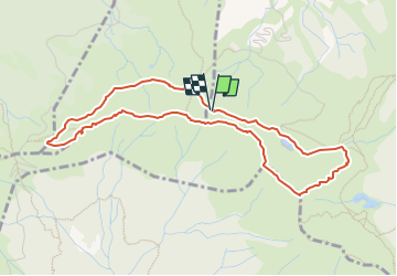
![](/images/other/stat-length.png)
![Tocht Te voet Abetone Cutigliano - 20220804 - Photo](https://media.geolcdn.com/t/1900/400/ext.pjpeg?maxdim=2&url=https%3A%2F%2Fstatic1.geolcdn.com%2Fsiteimages%2Fupload%2Ffiles%2F1545311037marcheuse_200dpi.jpg)
20220804
Maurizio Melandri
Gebruiker
![Lengte](/images/other/stat-length.png)
![Max. hoogte](https://static1.geolcdn.com/siteimages/upload/files/1508320355ic_sort_altitude_max_24dp.png)
![Positief hoogteverschil](https://static1.geolcdn.com/siteimages/upload/files/1508320355ic_sort_den_pos_24dp.png)
![Km-Effort](/images/other/stat-length.png)
![Min. hoogte](https://static1.geolcdn.com/siteimages/upload/files/1508320355ic_sort_altitude_min_24dp.png)
![Negatief hoogteverschil](https://static1.geolcdn.com/siteimages/upload/files/1508320355ic_sort_den_neg_24dp.png)
![Boucle](https://static1.geolcdn.com/siteimages/upload/files/16400158638029165_repeat_loop_refresh_sync_direction_icon.png)
![Te voet](https://static1.geolcdn.com/sitytour/trail-icons/100.png)
3h30
Moeilijkheid : Medium
![Scan deze QR-code om de tocht te openen in de SityTrail-applicatie](https://capi.geolives.com/qq0zvz2zws4bq2lad0pu/sitytour/trails/3342179/qr.png?size=200)
Gratisgps-wandelapplicatie
Over ons
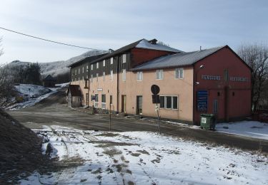
Tocht Te voet van 4,8 km beschikbaar op Toscane, Pistoia, Abetone Cutigliano. Deze tocht wordt voorgesteld door Maurizio Melandri.
Beschrijving
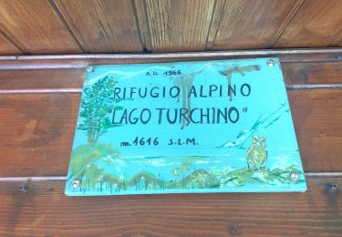
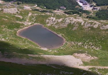
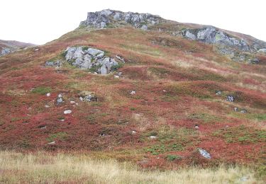
Dopo essere saliti con la seggiovia si prende il sentiero CAI 519 che porta al lago piatto, al bivio si prende il sentiero 00 che porta all'Alpe 3 Potenze prima asperità
Arrivati in cima si prosegue per Femmina Morta con la 00. Il percorso non è difficile, ma nemmeno facile, ci sono un paio di punti ostici
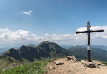
Superata Femmina Morta la 00 comincia a scendere fino a incrociare nuovamente il 519 che si riprende per arrivare prima al Passo di Annibale e, succesivamente. allaseggiovia
Plaatsbepaling
Opmerkingen
Wandeltochten in de omgeving
![Tocht Te voet Pievepelago - (SI L16) Lago Santo Modenese - Passo delle Radici - Photo](https://media.geolcdn.com/t/375/260/5e3e4a9c-3762-45fe-bacf-33e2f6ab55a3.jpeg&format=jpg&maxdim=2)
![Te voet Te voet](https://static1.geolcdn.com/sitytour/trail-icons/100.png)
Te voet
![](/images/other/stat-length.png)
![](https://static1.geolcdn.com/siteimages/upload/files/16400158638029165_repeat_loop_refresh_sync_direction_icon.png)
![Tocht Te voet Abetone Cutigliano - IT-507 - Photo](https://media.geolcdn.com/t/375/260/b0e1bc75-1c50-479c-ada2-a5db2babd61b.jpeg&format=jpg&maxdim=2)
![Te voet Te voet](https://static1.geolcdn.com/sitytour/trail-icons/100.png)
Te voet
![](/images/other/stat-length.png)
![](https://static1.geolcdn.com/siteimages/upload/files/16400158638029165_repeat_loop_refresh_sync_direction_icon.png)
![Tocht Te voet Pievepelago - (SI L16 OLD) Lago Santo Modenese - Passo delle Radici - Photo](https://media.geolcdn.com/t/375/260/5e3e4a9c-3762-45fe-bacf-33e2f6ab55a3.jpeg&format=jpg&maxdim=2)
![Te voet Te voet](https://static1.geolcdn.com/sitytour/trail-icons/100.png)
Te voet
![](/images/other/stat-length.png)
![](https://static1.geolcdn.com/siteimages/upload/files/16400158638029165_repeat_loop_refresh_sync_direction_icon.png)
![Tocht Te voet Abetone Cutigliano - (SI L15) Abetone (Boscolungo) - Lago Santo Modenese - Photo](https://media.geolcdn.com/t/375/260/d9c856e7-0fee-46cb-b1dc-d250ecd0b74b.jpeg&format=jpg&maxdim=2)
![Te voet Te voet](https://static1.geolcdn.com/sitytour/trail-icons/100.png)
Te voet
![](/images/other/stat-length.png)
![](https://static1.geolcdn.com/siteimages/upload/files/16400158638029165_repeat_loop_refresh_sync_direction_icon.png)
![Tocht Te voet Fiumalbo - IT-505 - Photo](https://media.geolcdn.com/t/375/260/ba8edcd9-6d4d-4a3d-9510-b543506f2742.jpeg&format=jpg&maxdim=2)
![Te voet Te voet](https://static1.geolcdn.com/sitytour/trail-icons/100.png)
Te voet
![](/images/other/stat-length.png)
![](https://static1.geolcdn.com/siteimages/upload/files/16400158638029165_repeat_loop_refresh_sync_direction_icon.png)
![Tocht Te voet Abetone Cutigliano - IT-100 - Photo](https://media.geolcdn.com/t/375/260/555a5dd0-53d5-431c-8b7e-814ca8ca46c4.jpeg&format=jpg&maxdim=2)
![Te voet Te voet](https://static1.geolcdn.com/sitytour/trail-icons/100.png)
Te voet
![](/images/other/stat-length.png)
![](https://static1.geolcdn.com/siteimages/upload/files/16400158638029165_repeat_loop_refresh_sync_direction_icon.png)
![Tocht Te voet Abetone Cutigliano - Sentiero del Tedesco - Photo](https://media.geolcdn.com/t/375/260/ab8c7a67-de8b-49bd-88d7-f633522fd8d7.jpeg&format=jpg&maxdim=2)
![Te voet Te voet](https://static1.geolcdn.com/sitytour/trail-icons/100.png)
Te voet
![](/images/other/stat-length.png)
![](https://static1.geolcdn.com/siteimages/upload/files/16400158638029165_repeat_loop_refresh_sync_direction_icon.png)
![Tocht Te voet Abetone Cutigliano - IT-519 - Photo](https://media.geolcdn.com/t/375/260/d9c856e7-0fee-46cb-b1dc-d250ecd0b74b.jpeg&format=jpg&maxdim=2)
![Te voet Te voet](https://static1.geolcdn.com/sitytour/trail-icons/100.png)
Te voet
![](/images/other/stat-length.png)
![](https://static1.geolcdn.com/siteimages/upload/files/16400158638029165_repeat_loop_refresh_sync_direction_icon.png)
![Tocht Te voet Pievepelago - IT-517 - Photo](https://media.geolcdn.com/t/375/260/f32fbdf8-e41e-4738-9caa-14faec4dc6b0.jpeg&format=jpg&maxdim=2)
![Te voet Te voet](https://static1.geolcdn.com/sitytour/trail-icons/100.png)
Te voet
![](/images/other/stat-length.png)
![](https://static1.geolcdn.com/siteimages/upload/files/16400158638029165_repeat_loop_refresh_sync_direction_icon.png)